
-
David Lawson, Wildlife Conservation Society
Afghanistan’s Non-Confrontational Conservation
›December 7, 2010 // By Wilson Center Staff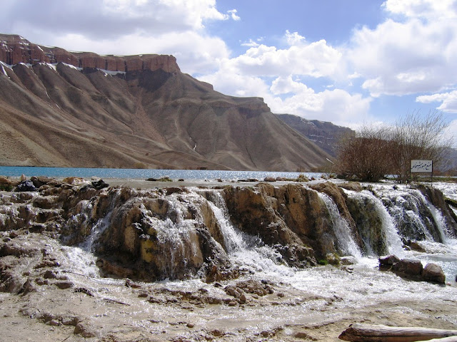
Excerpt from the Center for a Better Life:
Afghanistan is more than war and turmoil; it has a long and colorful history, strong cultures and a stunning landscape. It has enormous biodiversity, as it sits at the crossroads of what biologists call “biological realms.” The country, therefore, has plants and animals that also occur in Europe, northern Asia, India, south Asia and Africa. It has nine species of wild cats, which is the same as the whole of sub-Saharan Africa, as well as an estimated 800 plant species that occur nowhere else in the world. In other words, Afghanistan is worth attention in terms of its biodiversity alone.These natural resources are also critically important from the people’s perspective. After 30 years of conflict, more than 80 percent of Afghanistan’s population relies directly on natural resources for their livelihood. Most of the inhabitants are rural and desperately poor by world standards. Child mortality is the highest in the world, and their infrastructure is mostly broken down and inoperable. The economy is donor-dependent, and the Afghan government is still in its infancy. Outside the capital of Kabul, governance sometimes seems non-existent. As a result, movement away from the major population centers can be very risky due to the presence of various insurgent groups.
And yet, what is seldom mentioned in newscasts and media is that the Afghans are proud and resilient. They want what everyone else wants: education for their children, healthcare for the young and elderly, and reliable livelihoods to support their families. Then they want to get on with their lives in their own unique, culturally diverse way, free of violence and conflict.
Understanding Cultures
Understanding these things is one reason why the Wildlife Conservation Society (WCS) has been successful in Afghanistan. When hearing of the Society’s field work in this war-torn country, most people are surprised. They wonder how, with its pressing problems, Afghanistan can afford the time, let alone the resources, to conserve its remaining wildlife and wild places. But this is one of the core strengths of WCS – to offer assistance in conserving natural resources at a practical level within a country in need, like Afghanistan. As one of the oldest conservation organizations in the world, with more than 100 years of field conservation experience, the Society has extensive seasoning under extreme circumstances. Currently, WCS has more than 600 projects in place with 3,000 staff; and, many of these projects are in the most remote areas of the world.
Since 2006, USAID has supported WCS’s work in Afghanistan within three geographical areas – the northeast in Badakhshan Province’s Wakhan District, Bamiyan’s central province and the eastern, forested Nuristan province. Experts chose these areas because they believed they held the largest numbers of untouched remaining wildlife; this presumption generally proved correct. Through the years, WCS has created trust by having conservation teams on the ground and working year-round with local communities. Similar trust has been established with the relevant ministries by WCS’ central office, located in Kabul, through continuous presence and assistance.
Results are impressive. More than seven pieces of environmental legislation were enacted; 10,000 Afghans received conservation training; the first biological surveys in 30 years were completed (which doubled as crucial skills development exercises for Afghan scientists); the first wildlife/domestic stock disease assessments were accomplished, with corresponding human health effects, plus many more exemplary achievements. One of the more intriguing results was WCS’ ability to build local governance in the most remote communities, thus connecting communities that had seen no real government representatives for years. This link extended to district authorities then to provincial authorities, and finally to the Kabul central government. This extension of Afghanistan’s rule-of-law is paramount because it improves governance, which is one of the more crucial strategic needs in the country today.
How was a non-governmental conservation organization able to contribute to governance and rule-of-law? It is simple. Wildlife conservation is usually a non-confrontational issue, and most people, when exposed to the process, take an active interest and express opinions. Rural people have grown up with and are surrounded by wildlife everyday; they have local knowledge and feel comfortable discussing how things have changed. They want to be empowered to make natural resource decisions in the areas in which they live. WCS staff encourages local people to discuss species protection with their local and provincial governments. In some instances, WCS workers have taken government officers into communities that cannot recall ever seeing a government official. These processes and contacts evolve and can be used as basis for non-conservation related discussion. These processes and relationships become the building blocks for extending governance and empowering local communities. And, the process works.
Continue reading on the Center for a Better Life.
David Lawson is the Wildlife Conservation Society Afghanistan country director.
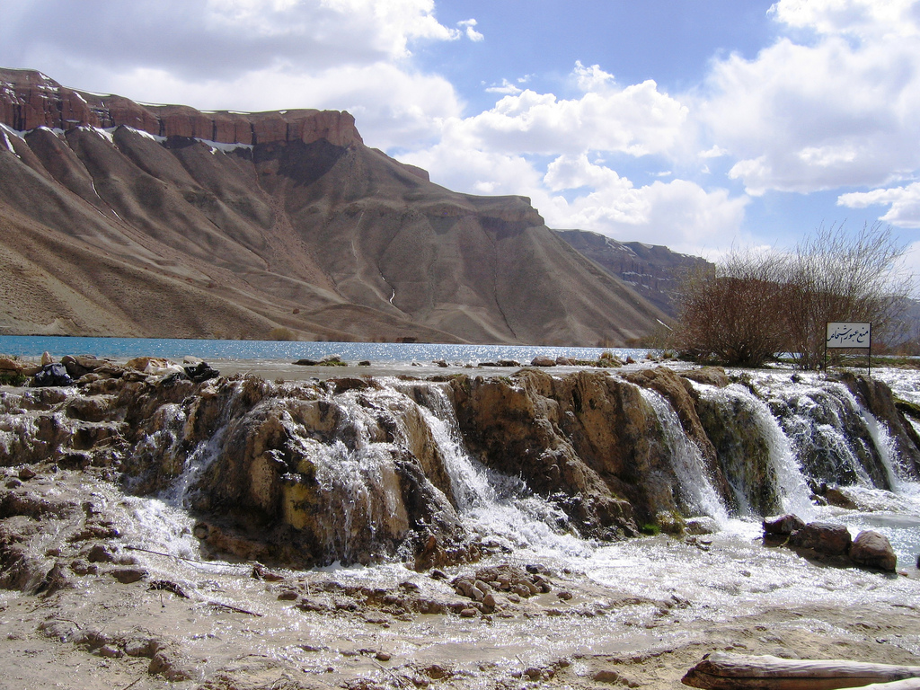
Photo Credit: “Bamiyan Band-e-Emir,” courtesy of flickr user USAID Afghanistan. USAID and WCS have been working in the Band-e-Amir lakes region since 2006 to create a national park. -
Meeting the Needs of Latin America’s Rural and Urban Populations
›October 14, 2010 // By Kayly OberThere are two Latin Americas according to demographers. In one of the most urbanized regions of the world, the population of some countries remains highly rural. While countries like Chile, Argentina, and Uruguay are close to 90 percent urbanized, much of Central America, as well as Ecuador, Paraguay, and Bolivia, are only about 50-60 percent urban.
Across the continent, Latin America’s total fertility rate has fallen from almost six children per woman in the 1960s to 2.2 children in 2005. Population growth rates are projected to continue to decline from 1.5 percent in 2010 to roughly 0.75 percent by 2020. But less-urbanized countries continue to experience high population growth in their rural areas, particularly among their large indigenous populations, who are not experiencing the same shifts from high to low fertility.
For example, since 1990, communities surrounding Guatemala’s Sierra de Lacandon National Park have grown by 10 percent each year, with birthrates averaging eight children per woman. These larger communities and households have led to agricultural expansion into the park, which has lost 10 percent of its forest canopy since 1990.
Rural-to-rural migration is also a key, but often overlooked, dynamic as migrants move to other rural areas in search of new land to farm. Between 1961 and 2001, Central America’s rural population increased by 59 percent. This increased population was accompanied by a 15 percent increase in deforestation, totaling some 13 million hectares.
Although many rural areas of Latin America have high fertility rates and expanding populations, they also have a high unmet demand for contraception. Indigenous populations are particularly underserved by health providers for many reasons, including cultural barriers, language, and accessibility. According to the Population Reference Bureau, an estimated 50 percent of indigenous women in the Ecuadorian Amazon do not want another child, yet 98 percent of them do not have access to a modern contraceptive method.
While reaching historically disadvantaged populations in rural communities is not easy, some programs have had considerable success—and saved money—by combining environmental and health efforts. For example, the Guatemalan NGO ProPeten trained more than 80 midwives and health promoters and developed a radio soap opera in both Spanish and Q’eqchi’ to deliver health services and environmental education to the communities living near the Maya Biosphere Reserve.
Given links between rural population growth and agricultural expansion, expanding access to family planning may not only be a cost-effective way to help women reach their desired family size, but also a smart investment in forest conservation and climate mitigation—and perhaps a down-payment on a more secure future for all. -
India’s Threat From Within
›Once a modest pro-peasant movement, India’s Maoist (or Naxalite) insurgency has become what New Delhi describes as the nation’s biggest internal security threat. The insurgency has spread to 20 of India’s 29 states, and across more than a third of the country’s 626 districts, most of them in the impoverished east. Earlier this summer, the Woodrow Wilson Center’s Asia Program, with assistance from the Environmental Change and Security Program, hosted, “The ‘Gravest Threat’ to Internal Security: India’s Maoist Insurgency,” to examine the insurgency’s main drivers, identify its prime tactics and strategies, and consider the best ways to respond.
Same Insurgency, Different Motivations
P.V. Ramana, a research fellow at the New Delhi-based Institute for Defense Studies and Analyses, discussed the motivations that draw people to the insurgency. Some people are aggrieved by the resource exploitations they witness in their villages. Others join the Maoist cause because of the “high-handedness” of Indian security forces. Still others do so because family members are already in the movement.
Ramana underscored a “serious disconnect” at play — people have such varied reasons for joining the insurgency, yet top Maoist leaders are inspired by one sole motivation: capturing political power. Ramana also highlighted the “increasing militarization” of the insurgency. Maoists have amassed an immense arsenal of weaponry, from “crude” tools to more sophisticated weapons such as rocket launchers and landmines. Their attacks increasingly target not only government security forces, but also national infrastructure such as power lines and railways.
Andhra Pradesh: Leading By Example
K. Srinivas Reddy, a Hyderabad-based deputy editor for The Hindu, offered a case study of the insurgency in his home state, Andhra Pradesh (AP), in southeastern India. He noted that New Delhi’s response to the insurgency in AP is often cited as a success story. This response, according to Reddy, can be attributed to an “attitudinal change” within the security ranks. From the 1970s through the mid-1990s — a period of mass Maoist recruitment and escalating insurgent violence — New Delhi’s counterinsurgency measures had been “panicky,” haphazard, and reactive, Reddy said. The “turning point” came in 1996, when a new “unity of thought” emerged within the government that emphasized better training of security forces, stronger intelligence, and greater attention to economic development. Later in the 1990s, security forces further softened their strategies and tactics, emphasizing “problem-solving rather than hunting Naxals.” As a result, in the early 2000s, popular support for Maoists in AP began to wane.
Is the Government Also to Blame?
Nandini Sundar, a professor of sociology at Delhi University, focused on the human impact of both the insurgency and the government’s response. Much of her presentation centered around Bastar, a sparsely populated, heavily forested, mineral-rich district of Chhattisgarh state — one of the areas hardest-hit by the insurgency. Maoist “entrenchment” is strong, she argued, because locals are treated so dreadfully by the government. “Very poor people are jailed” for committing minor forestry transgressions, Sundar explained, while “powerful people” get away with large-scale offenses. Additionally, the police are deeply unpopular and “a source of repression.” They also regularly rape women and extort money, she said.
Sundar identified and condemned a raft of repressive government policies — from throwing locals off their land to commandeering schools — and insisted that such repression constitutes the prime reason for recruitment to the insurgency. “Injustice more than inequality” explains why people join the Maoists, she said.
The panel was far from sanguine about the future. Ramana contended that immediate prospects for peace talks between the government and the Maoists are slim, and that civil society has been “quiet” and has offered little assistance. While he predicted that some sort of resolution could be reached in “7 to 10 years,” Sundar countered that the harsh nature of New Delhi’s response means that 7 to 10 years “could finish off” not just the Maoists, but also village populations.
Compounding the challenge is what Sundar described as “official contempt” toward the culture of the Adivasi, the tribal peoples of India whose homeland comprises the insurgency’s epicenter. Dehumanizing, anti-adivasi language from the government enables New Delhi to justify the waging of forceful counterinsurgency, Sundar argued.
Glimmers of Hope
Several speakers, however, gave reasons to be guardedly optimistic about the Maoist issue. Pointing to Maoist strategies in Andhra Pradesh, Reddy suggested that the insurgency’s poor policies could spell its demise. Maoists in this state chose to escalate violence, but their inability to spread their ideology along with this violence has cost them public support, particularly in urban areas. (A recent survey by The Times of India actually found that 58 percent of those in AP think Naxalism has been good for the area – a devastating poll for those in the government who thought they were winning there – Ed.)
Sundar, meanwhile, noted that much good would come out of simply implementing long-dormant constitutional protections for the rural poor in Maoist-affected areas. This, she concluded, would reflect rights-based development, which is necessary for success — as opposed to development based on “hand-outs” by the elite, which is destined to fail.
Michael Kugelman is a program associate with the Woodrow Wilson Center’s Asia Program.
For more on the resource conflict aspect of the insurgency see The New Security Beat’s, “India’s Maoists: South Asia’s ‘Other’ Insurgency.”
Sources: BBC, Foreign Policy, Times of India.
Photo Credit: Adapted from “CPI Flag (Andhra Pradesh),” courtesy of flickr user Shreyans Bhansali. -
“There Is No Choice:” Climate, Health, Water, Food Security Must Be Integrated, Say Experts
›August 9, 2010 // By Russell SticklorBureaucratic stovepipes plague international development efforts, and aid for pressing environmental and human security concerns—such as climate change, food shortages, fresh water access, and global health threats—rarely matches the reality on the ground in the developing world, where such health and environmental problems are fundamentally interconnected.
Instead, development efforts in the field—whether spearheaded by multilaterals, bilaterals, or NGOs—are commonly devoted to single sectors: e.g., the prevention and treatment of a single disease; the implementation of irrigation infrastructure in a specific area; or the introduction of a new crop in a certain region. The reasons for such a narrow focus can come from multiple sources: finite resources, narrowly constructed funding streams, emphasis on simple and discrete indicators of success, and institutional and professional development penalties for those who conduct integrated work. But some experts argue that integrating problem-solving initiatives across categories would not only improve the efficacy of development efforts, but also better improve lives in target communities.
As part of the USAID Knowledge Management Center‘s 2010 Summer Seminar Series, a recent National Press Club panel on integration featured a frank discussion of both the opportunities and challenges inherent in breaking down barriers within and between development agencies. Panelists from the World Bank’s Environment Department, the White House Council on Environmental Quality, and the Woodrow Wilson Center’s Environment Change and Security Program weighed in on the prospects for cross-sectoral integration.
Addressing the impacts of a global problem like climate change “requires multilevel approaches,” and necessitates that we “think multisectorally along the lines of agriculture, water, transportation, energy, [and] security,” said Loren Labovitch of the White House Council on Environmental Quality. The four topics under discussion—climate change, food security, water, and health—are all Obama administration priorities, as reflected by dedicated programs and special initiatives. Finding ways to practically integrate these interrelated challenges (through efforts like the Feed the Future Initiative or the Global Health Initiative) is getting more attention from policy analysts and policymakers with each passing year.
Integration in Practice: Success Stories
While there may be an emerging willingness to discuss and even experiment with holistic programming, what does it actually look in practice? Panelist Geoff Dabelko, director of the Woodrow Wilson Center’s Environmental Change and Security Program, singled out integrated development programs in the Philippines, the Democratic Republic of Congo, and Asia as examples.
Philippines: The PATH Foundation Philippines’ Integrated Population and Coastal Resource Management (IPOPCORM) initiative uses an integrated approach to address health and environmental concerns in coastal communities. Their “basket of services” includes establishing a locally managed protected marine sanctuary to allow local fish stocks to recover, promoting alternative economic livelihoods outside of the fishing industry, and improving access to local health services and commodities, said Dabelko. To date, IPOPCORM has yielded several notable improvements, among them reduced program costs and improved health and environmental outcomes as compared to side-by-side single sector interventions. A forthcoming peer-reviewed article will appear in Environmental Conservation, and will detail the controlled comparison study of the IPOPCORM project.
Democratic Republic of Congo: Mercy Corps has also successfully pursued cross-sectoral programming as part of a larger effort to be more holistic in its humanitarian and development responses. In war-torn eastern DRC, Mercy Corps brought practitioners with expertise in natural resource management into the fold of what has historically been an emergency relief mission. In particular, the Mercy Corps mission has fused humanitarian assistance with longer-term development efforts such as enhanced environmental stewardship. For example, promoting the use of fuel-efficient cookstoves eases pressure on local forest resources by lowering the need for firewood, and improves respiratory health by lowering air pollution. The project scaled up the effort through resources from further integration, with carbon credits from avoided emissions being sold through a local broker to the European cap and trade market. These resources in turn helped finance more cook stoves, which now total 20,000 for this project.
“The lesson is we have no excuse for not doing this anywhere in the world and saying some place is too unstable,” Dabelko said. “If we can do it [integrated projects] in eastern DRC, we should be able to do it anywhere.”
Asia: Tackling programmatic integration starts with better understanding the interconnections between environmental and health challenges. Dabelko cited a recent effort of the environment and natural resources team within USAID’s Asia Bureau as an example of breaking out of narrow bureaucratic stovepipes.
USAID staff recognized that a wide set of climate, energy, economic, governance, and conflict issues affected their core biodiversity and water portfolios, even if they did not have the time, expertise, or resources to investigate those issues in detail. Trends that appeared to be in the periphery were not viewed as peripheral to planning and designing programs for long-term success.
Working with the Woodrow Wilson Center, the USAID Asia Regional Bureau engaged experts on a diverse set of topics normally considered outside their portfolios. The resulting workshop series and report led to a deeper understanding of the possible impacts of increased Himalayan glacier melt and Chinese hydropower plans on food security and biodiversity programs in the lower reaches of the Mekong River. Bringing analysis from these topically and geographically remote areas into local-level development planning is a process that will require a similar willingness to go outside the typical bounds of one’s brief.
More Integration Ahead?
These case studies provide a glimpse of what integrated programming can look like on the ground. Still, significant hurdles remain standing in the way of regular and effective integration. Cross-sectoral programming demands that old problems be addressed in innovative and perhaps unfamiliar ways, requiring the addition of new capacity in development organizations and better coordination within and between agencies. That can be a complicated process, noted Dabelko, since efforts to pursue greater programming integration can be “hamstrung by earmarks and line items.”
Integration can also prove tricky because it requires a greater willingness to accept multiple indicators of success unfolding over different time frames—health gains may occur quickly, for example, while progress on environmental conservation may unfold less speedily. This means existing programs might need to be reshaped and reoriented to accommodate these divergent time frames, which could prove somewhat difficult. “Integration can be a challenge, both from a programming perspective and from an organizational perspective,” acknowledged moderator Tegan Blaine, climate change advisor for USAID’s Africa Bureau.
Further, the temptation remains strong among appropriators and implementers alike to maintain control over authority and resources in their traditional portfolios. Getting long-time practitioners in particular issue areas to willingly cede some of their turf in the pursuit of greater integration has historically been the “real world” that stands in the way of such integrated work.
But, as shown by the standing-room-only crowd at the seminar, momentum is slowly starting to build in pursuit of breaking down old programming walls and finding new approaches to addressing emerging challenges in human and environmental security.
“There is no choice” but to fuse development agendas with climate change adaptation efforts, asserted Warren Evans, director of the World Bank’s Environment Department. “It can’t be a parallel process anymore.”
Photo Credit: “2010 Summer Seminar Series – July 15th Panel Discussion on Food Security, Climate Change, Water and Health,” used courtesy of USAID and the National Press Club. -
Drug Barons, Poachers, Ranchers, Oh My! Guatemala’s Forests Under Siege
›July 29, 2010 // By Kayly OberLast week, the New York Times ran an article about the many threats converging on Guatemala’s Maya Biosphere Reserve. “There’s traffickers, cattle ranchers, loggers, poachers and looters,” Richard D. Hansen, an American archaeologist, told NYT. “All the bad guys are lined up to destroy the reserve. You can’t imagine the devastation that is happening.”
Eric Olson, senior associate of the Mexico Institute at the Woodrow Wilson Center, agrees that drug trafficking is a major problem in the Petén, a region of northern Guatemala that lies within the Biosphere. “Petén’s isolation has made it possible for the biodiversity of the area to survive and thrive during periods of great social turmoil, especially in the 1980s,” Olson told the New Security Beat. “However, the isolation also makes it an ideal place for drug traffickers to move their illegal product northward.”
According to NYT, peasant squatters in search of farmland constitute an additional threat because they “often become pawns of the drug lords,” and, in some instances, “function as an advance guard for the drug dealers, preventing the authorities from entering, warning of intrusions, and clearing land that the drug gangs ultimately take over.”
Plus, the situation seems poised to worsen. According to a UNESCO report, Petén’s population has surged from 25,000 during the 1970s to upwards of 500,000 today. This growth, coupled with an attendant rise in subsistence farming, has had significant environmental impacts across the region.
Population Growth in Protected Areas
“Population has a huge impact on Guatemala’s ecological diversity,” David López-Carr, an associate professor in the University of California-Santa Barbara’s Geography Department, wrote in an e-mail to the New Security Beat. Most striking, according to López-Carr, are total fertility rates in rural areas, which remain “over 5 and much higher still – higher than 6 – in the most remote rural areas where ecological diversity is highest.”
Despite the fact that most migrants move to Guatemala City, smaller cities, or the United States, López-Carr wrote that the “tiny fraction (probably under 5%) that move to remote rural areas have a major impact on biodiversity and forest conversion.” López-Carr pointed out that “in core conservation areas of the Maya Biosphere Reserve, in-migration has swelled the population in some regions by nearly 10% annually during the past two decades.”
At a 2008 meeting at the Woodrow Wilson Center, professors Justin Brashares and George Wittemyer said three factors drive population growth near protected areas in Africa and Latin America: 1) more money for parks (as measured by protected-area funds from the Global Environment Facility); 2) more park employees; and 3) more deforestation on the edges of protected areas.
To avoid population pitfalls, Guatemala’s President Alvaro Colom should take this research into account before putting his “Cuatro Balam” eco-tourism plan into action. The initiative—named for the four main figures in the Mayan creation myth—seeks to divide the reserve into an archaeological park in the north and an agricultural zone in the south, while setting up a Maya studies center for scholars and installing an $8 million electric mini-train to shuttle tourists through the reserve.
The Perils of “Pristine Conservation”
While President Colom’s plan is certainly ambitious, communities in Petén are cautious. They see Cuatro Balam as a continuation of earlier government-funded projects, where “pristine conservation” – oft-touted by large conservation organizations – prohibited human interaction with the forests and limited socioeconomic opportunities for local populations.
Liza Grandia, an anthropology professor at Clark University who has lived and worked in the Peten region, points out in Conservation and Society that “primary” or “pristine” forests flagged as biological hotspots by these conservation organizations are likely remnants of ancient Mayan agroforestry. However, Mayan descendents are not allowed to live within nor manage these areas.
Instead, stewardship of many federal parks is delegated to large conservation outfits or the government. But Rosa Maria Chan, director of ProPeten, a community-based environmental organization, wrote in an e-mail to the New Security Beat that “the environment is not always the government’s priority,” adding that “development” normally signifies large infrastructure projects, instead of smaller-scale ideas that would better address human development.
The Benefits of Community-Based Conservation
One successful local project is the Association of the Forest Community of Péten (ACOFOP), a community-based association made up of 23 indigenous and farming organizations. Under ACOFOP’s direction, uncontrolled settlement in the biosphere reserve has been stopped, communities have ceased the conventional slash-and-burn practices, and forest fires have virtually ceased in community-managed areas. ACOFOP’s projects have also created jobs in local communities, where the beneficiaries re-invest their earnings into collective infrastructure.
In the mid-1990s/early 2000s, ProPeten’s Remedios I and II programs, funded mainly by USAID, used radio soap operas and mobile theaters to educate residents about conservation, reproductive health, nutrition, and sustainable agriculture. Underlying these programs’ success was an unprecedented survey that gathered data on the rapidly changing population-environment dynamics in this frontier region.
Grandia, who served as head of ProPeten’s board of directors from 2003-2005, writes in 2004 Wilson Center article that “the integrated DHS [Demographic and Health Survey] has been a critical part of developing…programs linking health and population with the environment,” which lowered Petén’s total fertility rate from 6.8 to 5.8 children per woman in just four years. Plans are underway to include a similar environmental module in the next DHS survey.
Although the fate of Guatemala’s forests is subject to many outside forces, from the government’s development plans to the cartel’s smuggling operations, small-scale, community-based programs may have the best shot at transforming the drivers of deforestation into sustainable, economic development opportunities.
Photo Credit: “Keel-billed Toucan at Tikal National Park, Guatemala,” courtesy of flickr user jerryoldenettel. -
India’s Maoists: South Asia’s “Other” Insurgency
›July 7, 2010 // By Schuyler NullThe Indian government’s battle with Maoist and tribal rebels – which affects 22 of India’s 35 states and territories, according to Foreign Policy and in 2009 killed more people than any year since 1971 – has been largely ignored in the West. That should change, as South Asia’s “other” insurgency, fomenting in the world’s largest democracy and a key U.S. partner, offers valuable lessons about the role of resource management and stable development in preventing conflict.
-
Visualizing Human and Natural Resources
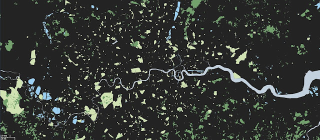
›In the policy world, statistics, percentages, and budgets on the order of millions and billions are routinely thrown around. But what do six and a half billion people, 957 tonnes per second, or three trillion dollars really look like?A visualization of London’s natural resources – grass, trees, and water only – by Adam Nieman.
Visual artist Adam Nieman recently received attention from The New York Time’s Dot Earth Blog for his illuminating scale models of hard-to-envision quantities such as the volume of oil being leaked from the Deepwater Horizon wells, global carbon emissions as measured in “UN Building units per second,” and the relatively small amount of air and water on Earth.
Demographers and sustainability experts often warn about the increasingly smaller allotment of natural resources per capita, but few have illustrated that reality at such a human scale as Nieman does.On a global level, Nieman’s work shows the tremendous population density of the world’s “urban island.” Over half of the global population now lives in cities, which is represented by the grey dot, just 616 km across in “Land-Cover Islands.”
Others seeking to improve quantitative visualizations include David McCandless of the site Information Is Beautiful. Among other things, McCandless has tackled the daunting task of accurately comparing spending in an age of trillion dollar budgets, with his “Billion Dollar Gram.”
Another group, the Dutch firm TD Architects, highlights the disparity between global demographics and the distribution of wealth with “Walled World.”
Nieman’s blog examines the confusion that often occurs at the interface between the political and scientific worlds. This confusion is amply demonstrated by debates over contentious issues such as budget priorities, population growth, and climate change.
Politicians often ask that complex problems be distilled into simple bullet points for speeches and policy documents. However, when it comes to problems of such complexity and scale, pictures like these may be worth a thousand bullet points.
Sources: New York Times, Reuters.
Photo Credit: “Green London (wide)” and “land cover islands” courtesy of flickr user JohnJobby. -
Urbanization, Climate Change, and Indigenous Populations: Finding USAID’s Comparative Advantage
›May 26, 2010 // By Kayly Ober“Part of the outflow of migrants from rural areas of many Latin American countries has settled in remote rural areas, pushing the agricultural frontier further into the forest,” writes David López-Carr in a recent article in Population & Environment, “The population, agriculture, and environment nexus in Latin America.” In a May 4 presentation at the LAC Economic Growth and Environment Strategic Planning Workshop in Panama City, Panama, he discussed how to integrate family planning and environmental services in rural Latin America.
Latin America is one of the most highly urbanized continents in the world, with an average of 75 percent of the population living in cities. However, “there are two Latin Americas,” said López-Carr at the workshop, which was sponsored by the Woodrow Wilson Center’s Environmental Change and Security Program and Brazil Institute, as well as the U.S. Agency for International Development. Largely developed countries like Chile, Argentina, and Uruguay are close to 90 percent urbanized, while Guatemala, Ecuador, and Bolivia are about 50 percent. In less urbanized countries, rural-rural migrants in search of agricultural land remain a major driving force behind forest conversion, he said.
Between 1961 and 2001, Central America’s rural population increased by 59 percent, said Lopez-Carr. The increasing density of the rural population had a negative impact on forest reserves: a 15 percent increase in deforestation totaling some 13 million hectares.
“Rural areas of Latin America still have high fertility rates but (unlike much of rural Africa, for example) also have a high unmet demand for contraception, meaning that improved contraceptive availability would likely result in a rapid and cost-effective means to reduce population pressures in priority conservation areas,” he said. Additionally, remote rural areas with high population growth rates tend to be associated with indigenous populations located in close proximity to protected forests.
For example, in Guatemala, communities surrounding Sierra de Lacandon National Park have, since 1990, grown by 10 percent each year, with birthrates averaging eight children per woman. Larger communities and larger households have led to agricultural expansion, which infringes on the park and accelerates deforestation in one of the most biologically diverse biospheres in the world, said López-Carr.
Based on these demographic and environmental trends, López-Carr suggested USAID’s work in the region should focus on rural maternal and child health, and education – especially for girls. Not only does USAID already invest in such programs, but they only cost pennies per capita and could reduce the number of rural poor living in Latin American cities by tens of millions.
Given the strong links between population density and deforestation in Latin America, expanding access to family planning would also be a smart investment in forest conservation and climate mitigation, López-Carr concluded.
Source: Population Reference Bureau.
Photo Credit: Dave Hawxhurst, Woodrow Wilson Center.
Showing posts from category forests.


