-
Youth Bulge, Public Policy, and Peace in Pakistan
›October 26, 2012 // By Payal Chandiramani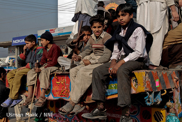
While Pakistan’s demographic challenges are perhaps well known – two-thirds of the population of 180 million is under 30 years old – increasing security concerns have prompted discussions about exactly how much the country’s youthfulness is affecting its prospects for peace. On October 10, the U.S. Institute of Peace and George Mason University’s School of Public Policy hosted a day-long conference on “Youth Bulge, Public Policy, and Peace in Pakistan” to tackle this question.
-
The Role of Renewable Natural Resources and Gender in Conflict
›
Devesh Kapur, Kishore Gawande, and Shanker Satyanath open their Center for Global Development working paper, “Renewable Resource Shocks and Conflict in India’s Maoist Belt,” with a crucial question: “Is there a causal relationship between shocks to renewable natural resources, such as agricultural and forest lands, and the intensity of conflict?” While the connection between the environment and conflict has been the focus of much study, Kapur et al. say that previous attempts have been plagued with “failure to address reverse causality and a failure to systematically control for alternative explanations for conflict.” Their report analyzes the relationship between the availability of resources and conflict by measuring rainfall, vegetation prevalence, and deaths due to the Maoist conflict in India. They find “a strong and substantively large relationship between adverse renewable resource shocks and the intensity of conflict,” and conclude that protecting the livelihoods of residents of the Maoist belt can help reduce violence. “Giving tribals greater access to forests and a range of forest products, whose consumption is the only available option during times of distress, can provide them with a critical self-insurance mechanism.”
-
Michael Klare on the Race for What’s Left
›Around the world, as the most easily accessible natural resources are depleted, states are beginning to turn to more remote reserves to meet their needs and the shift may spark international tensions or even conflict, said Hampshire College professor Michael Klare in a recent interview with ECSP. “I worry very much about this growing global competition for the remaining resources in those parts of the world,” he said.
-
Jill Hagey, Behind the Numbers
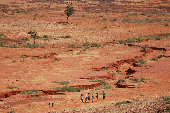
Sahel Drought: Putting Malnutrition in the News
›The original version of this article, by Jill Hagey, appeared on the Population Reference Bureau’s Behind the Numbers blog.
Over the past few months, the Sahel drought has sparked attention of news media and concerned citizens around the world. Throughout this media blitz, I have been struck by the sharp contrast between this coverage and how the devastating effects of malnutrition are usually portrayed. Malnutrition is often overlooked in favor of more “newsworthy” diseases, and it takes a crisis to focus our attention on this public health issue. Yet an emergency such as this drought – affecting more than 18 million people, including nearly 2 million children – is difficult to ignore.
-
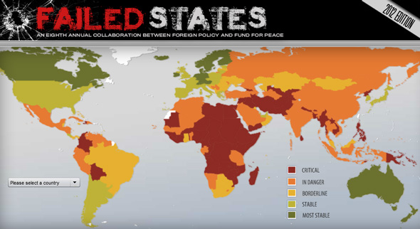
Another Year, Another Debate: Is the Failed States Index Simply Misnamed?
›Every year, there are mixed reactions over the rankings and the efficacy of the Fund for Peace’s Failed States Index (FSI), the eighth edition of which was released in June. But this year, the criticism seems especially intense.
“Failed means there is no way back. Failed means a binary division between those countries that are salvageable and those beyond redemption. It is a word reserved for marriages and exams. It does not belong in a pragmatic debate,” wrote Claire Leigh for The Guardian in June.
-
Emmanuel Karagiannis: Mediterranean Oil and Gas Discoveries Could Change Regional Alignments, Global Energy Equation
›“The discovery of gas reserves in the eastern Mediterranean comes at a time when world demand for energy is growing rapidly and many are questioning the reliability of supplies from North Africa and the Middle East,” said Emmanuel Karagiannis, assistant professor of Russian and post-Soviet politics at the University of Macedonia, in an interview at the Wilson Center.The newly-discovered fields contain about 122 trillion cubic feet of recoverable natural gas reserves, 25 trillion of which are located within Israeli territorial waters. “That’s twice the reserves Libya has,” according to Karagiannis. The remaining fields have been claimed by the Republic of Cyprus, the Turkish Republic of Northern Cyprus, Syria, and Lebanon.
Europe currently depends on Russia for most of its gas supplies, so the new fields could provide an “important alternative source for European economies,” said Karagiannis.
The discovery also has the potential to increase stability in the region by serving as an incentive for nations to work together. “For example, Israel and Cyprus have come closer to each other in many respects, including military cooperation,” Karagiannis said. Greece and Israel have also strengthened their relationship, in part due to the historical relationship between Cyprus and Greece but also because the latter could serve as an energy hub to transport gas throughout Europe, he said. “In effect Israel, Greece, and Cyprus could form a new axis of stability in the region.”
“Turkey can also play a significant part in the business of transporting energy resources to Europe,” Karagiannis said, but Syria and Lebanon, the two other countries that lie adjacent to the newly discovered gas reserves, are less likely to benefit in the near future from the find, given their current political circumstances. “It’s very difficult to imagine their participation in the regional energy projects,” he said. Lebanon has tried and failed to sell offshore exploratory licenses twice due to its lack of a state petroleum administration, while the current uprising against President Bashar al-Assad is preventing any progress in Syria.
In part as a result of these political challenges, the gas fields also have the potential to generate conflict in the region. There will be a divide between “haves and have-nots,” explained Karagiannis. According to a report by the Institute for National Strategic Studies, “piping Israeli gas to the RoC [Republic of Cyprus] and then onto Turkey, which could be the gateway to the European market, is unlikely due to current tensions between Ankara, the RoC, and Tel Aviv.” Since the discovery of the fields, “Turkey has already issued military threats against Cyprus in order to stop the gas exploration process that is currently taking place in the Cypriot Exclusive Economic Zone,” Karagiannis said. The Israeli government issued a response to the threat, stating that they are committed to protecting energy infrastructure in the region.
The first new natural gas field in the region is expected to begin full-scale production this year, with two additional fields coming on-line over the next six years.
Keenan Dillard is a cadet at the United States Military Academy at West Point and an intern with the Woodrow Wilson Center’s Environmental Change and Security Program.
Sources: Institute for National Strategic Studies, Noble Energy Inc., Turkish Weekly, U.S. Geological Survey. -
Population Aging: A Demographic and Geographic Overview
›The original version of this article, by Richard Cincotta, appeared on the National Intelligence Council’s Global Trends 2030 Blog. It is the first post in a series on population aging, featuring Jack Goldstone, Richard Jackson, Jennifer Dabbs Sciubba, Ronald Lee, Andrew Mason, Toshi Yoshihara, Elizabeth H Stephen, David Coleman, and Eric Kaufmann.
This series, Population Aging to 2030, begins with an introductory essay aimed at familiarizing readers with some of the demographic and geographic particulars of this phenomenon, and with several key demographic terms. The term most in need of definition is, of course, “population aging.” -
Visualizing Complex Vulnerability in Africa: The CCAPS Climate-Conflict Mapping Tool
›“Every crisis is complex, and the Sahel is no exception,” wrote USAID Assistant Administrator Nancy Lindborg in a recent Huffington Post article that called for “smarter programming and a coordivenated response” to chronic crises. “A regional drought has been overlaid with instability stemming from the coup in Mali and conflict in the northern part of that country where armed militant groups have forced the suspension of critical relief operations” and led to refugee movement into neighboring countries simultaneously challenged by drought and crop infestation. Understanding the complexity of this type of crisis, let alone visualizing the multiple factors that come into play, is a growing challenge for policymakers and analysts.
Enter version 2.0 of a mapping tool created by the Climate Change and African Political Stability Program (CCAPS) housed in the Robert S. Strauss Center for International Security and Law, based at the University of Texas, Austin.
In collaboration with the College of William and Mary, Trinity College, and the University of North Texas, and with funding by the U.S. Department of Defense’s Minerva Initiative, CCAPS originally launched the mapping tool in March of this year. The map is powered by mapping and data tools from Esri and allows users to view any combination of datasets on international development projects, national governance indicators, incidences of conflict, and climate vulnerability data.
With an intuitive interface and compelling visuals, the mapping tool is a valuable resource for policy analysts and researchers to assess the complex interactions that take place among these environmental, political, and social factors. Advanced filters allow the user to identify a subset of conflicts and aid projects and there are nine base map styles from which to choose.The mapping tool is anything but static. The team is constantly working to refine and enhance it through the inclusion of additional indicators and improvement of the interface. The updated version now includes CCAP’s new Social Conflict in Africa Database, which tracks a broad range of social and political unrest, and their partners’ real-time conflict dataset, the Armed Conflict Location and Event Dataset (ACLED), which tracks real-time conflict data. Impressively, the ACLED data will be updated weekly.
I asked CCAPS program manager Ashley Moran to clarify how the governance indicators work in the model. She explained:The national governance indicators are included in one of four baskets that make up the climate vulnerability model…and represent four potential sources of vulnerability: physical exposure to climate-related hazards, population density, household and community resilience, and governance and political violence. They used the term “basket” since most include several indicators that reflect the full dimensions of that source of vulnerability. The fourth basket includes five national governance indicators and one indicator of political violence.
Moran also shared plans to add more detailed national governance data to the map:We are developing a mapping tool specifically for the climate vulnerability model, which will allow users to see the component parts of the model. It will allow users to re-weight the baskets (e.g. if a user thought governance should have more weight within the model since the government response to climate hazards is key), and it will also allow users to examine an area’s vulnerability to just one or two baskets of the user’s particular interest (instead of all four baskets combined as the tool does now). When we launch this, a user will essentially be able to see the vulnerability model disaggregated into its component parts, so they’ll be able to map just the governance data in the model, if they want.
In the coming months, the CCAPS team will add more detailed historical and projected data on climate vulnerability, data on disaster response capacity, as well as international aid projects coded for climate relevance.
Each of these datasets on their own are a wealth of vital information, but understanding how they intersect and the potential impact of their interactions is crucial to improving our understanding of them individually and collectively and creating responses that are timely and long-lasting.
If you’re in the San Diego area next week, check out Ashley Moran’s presentation of the mapping tool at the Esri International User Conference and the Worldwide Human Geography Data Working Group.
Sources: The Climate Change and African Political Stability Program, The Huffington Post.
Image Credit: CCAPS
Showing posts from category foreign policy.