-
To Build or Not to Build: Western Route of China’s South-North Water Diversion Project

One of the biggest challenges facing China’s future development is water, which must support the country’s 1.4 billion people and booming industries. Despite being one of the top five countries with the largest freshwater resources, on a per capita basis, China faces serious water shortages which are further compounded by a highly uneven spatial distribution and precipitation: the densely populated north suffers from acute water shortages whereas the south is prone to severe floods. To optimize the allocation of water resources, China has embarked on the construction of a mega engineering project, the South North Water Diversion project (SNWD).
Expanding the world’s largest water transfer project
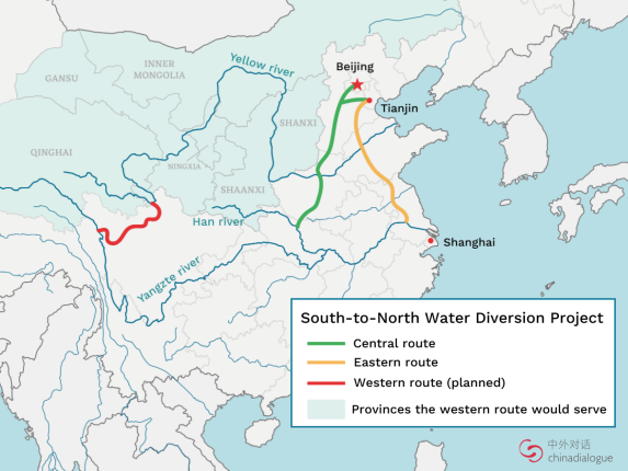
The project was first proposed in 1952 by Mao Zedong who concluded that “the south has plenty of water, the north much less. If possible, the north should borrow a little.” And the SNWD does exactly that — it diverts water from the South to the North along three routes: eastern, middle, and western. The eastern route transfers water through Jiangsu to Shandong and Tianjin via the Beijing-Hangzhou Grand Canal, which dates back to nearly 2,500 years ago. The middle route, diverting water from Hubei province to Beijing and Tianjin, has been in use since 2014.
The western, and most controversial route, has not yet been built. In May 2021, Chinese President Xi Jinping announced that China will press ahead with the world’s largest water diversion project. The western route’s plans are split into two categories: modest plans from the government and ambitious proposals from scholars.
Various plans for the western route
The official plan for the western route links the Yangtze and Yellow rivers across the Qinghai-Tibet Plateau to divert 17 billion m3 of water, approximately 7 million Olympic-sized swimming pools, to Gansu and neighbouring provinces each year. This transfer is massive, but notably much smaller than two alternate water transfer plans targeting water from the Qinghai-Tibetan plateau.
The Shuotian Canal (Great Western Route) was an earlier proposal by water expert Guo Kai in the 1990s. By building a dam in Tibet, 200 billion m3 of water could be diverted from Sichuan to Beijing and Tianjin. It was later concluded that the Shuotian Canal is neither technically feasible nor necessary.
Another proposal from 2017 on the Red Flag River was introduced by Tsinghua professor Wang Hao. It plans to annually divert 60 billion m3 of water from transboundary rivers on the Qinghai-Tibetan Plateau, including the upstream of the Brahmaputra, Mekong, and Salween, to northwest China. This would create 200 million mu (133,333 km2) of arable land in Xinjiang and a 150,000km2 greenbelt in the northwest. However, its feasibility has been questioned by academics and geographers.
As a possible alternative to the western route, the Tianhe project, the world’s largest weather modification and artificial rainmaking system, was proposed by scientists from Tsinghua and Qinghai universities in 2015. The Tianhe project uses glaciogenic cloud seeding to annually create 5-10 billion m3 of rain above northern China. It was included in Qinghai’s 13th Five Year Plan.
National food security driver and environmental concerns
The western route is needed to safeguard the country’s water and food security while balancing regional economic development. As Xi Jinping stated in 2014, the lifeline of food production lies in the country’s water conservancy systems. Aside from grappling with national water quality, quantity, and unequal distribution, China faces a lack of arable land: estimates suggest that only 14 percent of the country’s total land is arable. With the remainder heavily contaminated by pollutants, this aggravates water scarcity, food safety, and food security concerns. Due to a changing dietary landscape, including increased demand for water-intensive produce like meat, these challenges will continue to increase. Hence, to the Chinese leaders, the western route could solve northern China’s water shortage problems and protect China’s overall food security.
Social and ecological concerns raised by environmentalists and scientists have delayed the construction of the western route. As both the Shuotian Canal and Red Flag River would need to cross earthquake-prone areas and mountain ranges, there are fears that they could result in seismic and environmental consequences such as landslides.
Competing local interests
Unlike the central government, provincial governments are less concerned about equity of access to resources. On the one hand, southern provinces from where water will be transferred, particularly Sichuan and Hubei provinces, which are located at the Yangtze River’s upstream, strongly oppose the western route. Not only does diverting water from these provinces threaten their own water supply, leading to fears of water scarcity and droughts, but it would additionally undermine the local hydropower sectors. In Sichuan, home to China’s largest hydropower sector, governments have publicly supported local scientists who strongly dispute the western route’s feasibility.
On the other hand, western provinces, such as Gansu and Qinghai, support the western route. They believe it will encourage regional socio-economic development by providing water for local industries, coal, and agriculture. Given their huge water demand, western provinces prefer the ambitious unofficial proposals. For example, the Gansu provincial government has provided support for research on various options to divert waters from Tibet (the Brahmaputra River) to Gansu.
International implications
India has long worried over China’s plans to divert the Brahmaputra, fearing it could cause water shortages. This is, however, a misperception: the official western route plans to divert waters from the Yangtze and Yellow rivers, not from transnational rivers like the Brahmaputra. Additionally, these unofficial proposals are not being seriously considered by the central government.
Furthermore, there is no consensus on the actual impacts from the plans on the downstream region’s water supply. To some Indian scholars, China’s water ambitions and perceived weaponization of water have caused alarm. As little as seven percent of the Brahmaputra’s flow comes from China, so even if the radical Shuotian Canal and Red Flag River are constructed, the actual impacts on water flows downstream will be limited.
Nevertheless, the strategic implications of these projects should not be overlooked. To some, the potential ability to manipulate the water flows could provide China strategic leverage over India.
An alternative route for water supply
Rather than relying on these mega projects to address national water challenges, China should reduce rising water demand, improve water use efficiency, and tackle water pollution. Given agricultural water demand accounts for most of the country’s water usage, China should balance water and food security, and consider undertaking regional and structural reforms to its agricultural sector.
Hongzhou Zhang is a Research Fellow with the China Programme at the S. Rajaratnam School of International Studies (RSIS), Nanyang Technological University, Singapore. His main research interests include China and regional resources governance (food, water, fisheries, land, and energy).
Genevieve Donnellon-May is a research assistant with the Institute of Water Policy (IWP) at the National University of Singapore. Her research interests include China, Africa, and the food-energy-water nexus.
Sources: American Geophysical Union, BNN Bloomberg, CGTN, China Daily, China Dialogue, China Water Risk, Chinanews.com, China.org.cn, Chinese Academy of Sciences, CSIS, CNKI, Earth.org, Gansu Post, IDSA, IWHR, Jiemian.com, mint, National University of Singapore, NetEase, New York Times, Post, ScienceDirect, Sohu.com, South China Morning, The Diplomat, The Economist, The Times of India, Wiley, Xinhuanet.com.
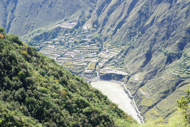
Lead Photo Credit: View of the Yalong River, which is one of the three tributaries of the Yangtze that will supply water for the western canal, courtesy of Rivina/Shutterstock.com.
 A Publication of the Stimson Center.


