-
Maps of Mayhem: Predicting the Location of Civil War Violence
February 21, 2018 By Jesse Hammond
Over the past decade, we have seen a resurgence of civil conflicts in Africa, the Middle East, and southeast Asia, as weak states are increasingly threatened by non-state actors, such as organized crime groups, terrorist organizations, and insurgents. These wars endanger millions of people—including some of the world’s most at-risk populations—by exposing them not only to violence, but also displacement, environmental degradation, and economic destruction. To effectively protect them, leaders and policymakers need to be able to predict exactly where, when, and how insurgent violence will break out and spread.
Current theories of civil war violence tend to assume that insurgents pick targets to attack largely based on the potential economic value (from rents and taxes or crime and looting) of a successful operation. Local populations, economic prosperity, and the presence of natural resources have been shown to attract violence from insurgents seeking material gain. However, the rhetoric that many insurgent groups use, and the way they carry out their campaigns against the state, suggests that their strategic logic is more complex than these theories suggest.
Identifying Strategic Location
Current theories are not wrong, but they are incomplete. While insurgent groups do seek economic gains, the actual work of carrying out a successful military campaign cannot simply revolve around looting and hiding from the government. Insurgents that want to carve out an autonomous zone of control within the state—either as their ultimate political goal, or as an intermediate step to building strength and stockpiling resources—have to take and hold strategically important locations to both defend their own territorial gains and launch attacks into government-held territory.
Consider the case of Blama, a small town in eastern Sierra Leone, that was fought over repeatedly during the 11-year civil war between the government and the Revolutionary United Front. Blama is not particularly large or prosperous, even by local standards. However, Blama’s location matters: The town sits at a crossroads connecting alluvial diamond fields near Koidu to the north, the second-largest city of Bo to the west, and the country’s second major airport in Kenema to the east. In other words, Blama occupies a strategically important position in the road network: The group controlling this town controlled access to much of eastern Sierra Leone, thus making Blama a logical target.
Strategic location is a concept that is easy to identify but hard to formalize. Generally, strategically located places are those that control access through the state: The party in control of such a location can monitor or block its opponent’s movement, providing a local military advantage. Major battles, from Thermopylae to Stalingrad to Cuito Cuanavale, have been fought over strategically important locations that both sides recognized as being essential to achieving their goals.
So why isn’t there more focus on strategic location in civil conflict analysis? The gap may be a side effect of the recent proliferation of high-quality GIS data. While it is relatively easy to acquire data on lootable resources, mountainous terrain, and local population, both the available data and dominant methodologies in the study of political violence are not well suited to understanding or modeling the impact of strategic location. And while there are specific examples immortalized in military history, it is much more difficult to create a clear set of rules that can be used to identify which cities and towns occupy key strategic locations before conflict begins.
Social Network Analysis: A Tool for Understanding Conflict
Classifying cities, towns, and villages based on their potential strategic importance can help us better explain and predict where insurgents and states will use violence during a civil conflict. In my recently published study on strategic location, I examined road infrastructure networks using social network analysis tools. Understanding the network geography of a country can help us identify why, where, and how insurgents use violence during civil war.
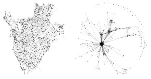
To identify local strategic importance, I focus on the road networks that connect cities, towns, and villages within the state. Roads are conduits along which people, goods, and information travel; during wartime, both state forces and insurgents rely heavily on these connections to transport fighters and materials. Roads determine access from one point to another, so we can identify strategic towns by looking at how they control access along the road network. The plots below show the town-road network in Burundi, viewed first as a geospatial map and then as a network graph:

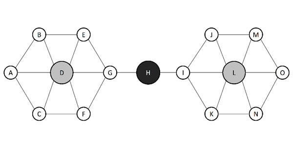
By understanding the state as a set of towns embedded in the national road network, I can leverage tools and theory from social network analysis to quantify how “important” a given town is from a network-centric point of view. In particular, I focus on the role of what is called “betweenness centrality” in the road network. Consider the road network below:

Town H has high betweenness centrality. In plain language, Town H occupies a chokepoint: traveling from one side of the map to the other forces passage through Town H. The group controlling Town H controls access through the road network. This measurement maps intuitively onto the idea of strategic location. The group that controls a chokepoint town can defend incursions from its opponent, and monitor or extract rents from the civilian traffic passing through. This approach provides a simple but useful rule set to identify key locations that are more attractive to insurgents seeking to control territory, and therefore could potentially face higher risks of violence during a conflict.
Strategic Location Matters
In my study, I use UCDP’s Georeferenced Event Dataset to analyze civil war battles in 32 countries over a 26-year period from 1989 to 2015. Statistical modeling of these data shows that strategically important towns are more likely to be fought over during civil conflicts, even after accounting for a wide range of common explanations. Insurgents that seek to control territory and expand their military and political reach are more likely to target towns that occupy strategic locations—not just those that contain lootable resources or easy recruits for future fights.
Civil war remains a massive threat to human security, even in an era where interstate conflict is becoming rarer. To effectively identify and target at-risk populations for humanitarian or military aid, leaders and policymakers need to understand how local-level factors affect the probable locations of insurgent violence. In addition, understanding strategic location may also change how we investigate the spatial relationships between natural resources, environmental conditions, and conflict.
Insurgents care about more than looting resources and avoiding capture: Taking and holding strategically valuable towns is an important step to military success. This logic of territorial control has not been accounted for in the current scholarship on civil conflicts, but my analysis suggests that it is worth further exploration if we want to better understand—and prepare for—the where, when, and why of violence during civil war.
Jesse Hammond is assistant professor of defense analysis at the Naval Postgraduate School in Monterey, California. His research focuses on leveraging social network analysis to address security issues.
Sources: Christian Science Monitor, Council on Foreign Relations, History Net, International Growth Centre, International Journal of Security and Development, Journal of Conflict Resolution, Journal of Peace Research, The National Interest, New Scientist, Political Geography, UCDP Georeferenced Event Dataset, Uppsala Conflict Data Program, Washington Post
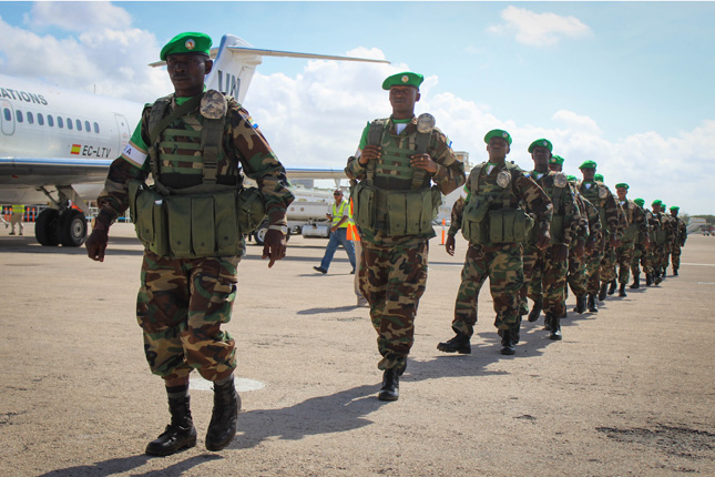
Photo Credit: Soldiers of the Republic of Sierra Leone Armed Forces disembark from a plane at Aden Abdulle International airport following their arrival in the Somali capital Mogadishu, June 2013. AU-UN IST PHOTO / RAMADAN MOHAMED
 A Publication of the Stimson Center.


