-
As Glacial Floods Threaten Mountain Communities, a Global Exchange Is Fostering Adaptation

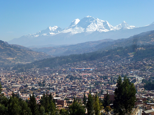
In 1941, glacial Lake Palcacocha in the Peruvian Andes burst its moraine dam of earth and stones, sending a torrent of water through the city of Huaraz and killing an estimated 5,000 people. Between 1941 and 1950, two more glacial lake outburst floods, or GLOFs, which can occur after enough water fills in behind a glacier’s end moraine, killed another 5,000 people in the Cordillera Blanca. In response, the government set up one of the most effective glaciological units in the world with the goal of preventing future outburst floods. Using drain pipes, reinforced terminal moraine dams, sophisticated tunnels, and valve systems, they drained or contained 34 lakes in the region. As a result, thousands of lives were saved.
From 1941-1950, 10,000 people were killed by glacial lake outburst floods in PeruBut Peru is not the only country in the world facing mortal threats from GLOFs and other changes to glacial stability. In response, The Mountain Institute has conducted a series of workshops facilitating exchange between mountain communities and scientific experts around the world with the aim of learning from past efforts and encouraging locally led adaptation to climate change.
Understanding changes in the world’s glaciers, including the threat from glacial lakes, is essential for mountain people as well as the millions of people living downstream who depend on freshwater from the mountains to survive. Peru’s Pacific coast, for example, is not only home to nearly 70 percent of the country’s population but is also its agricultural bread basket – and totally dependent on water from the High Andes to the east.
From Peru to Nepal and Back
In September 2011, 35 scientists trekked deep into the Himalayas to set up a base camp at 5,000 meters near Imja Lake – one of the most dangerous glacial lakes in Nepal. They came from 15 countries to provide tangible solutions to the threat of GLOFs by combining the latest science with accumulated traditional knowledge from different parts of the world.
Until the 1950s, Imja was a debris-covered glacier. Soon small meltwater ponds began forming behind the glacier terminus. In the following decades these ponds merged and grew into an enormous and rapidly expanding lake. Today, Imja Lake covers a square kilometer and contains over 75 million cubic meters of water, the equivalent of 26,000 Olympic swimming pools. Even more alarming is the rate at which it is lengthening – more than 75 meters per year.
An outburst could threaten much of the Khumbu Valley, home to Mount Everest and one of Nepal’s most popular trekking destinations. Thousands of hikers, porters, and local people are in danger of losing their lives, property, livestock, and livelihoods in the event of a flood. Such a disaster could measurably reduce the GDP of this desperately poor country for years to come.
Prior to our expedition, Sherpas and other indigenous people sensed danger from Imja Lake, but had little recourse. They had watched visiting researchers come and go for years, but most outsiders did not share their findings or offer solutions.
They had watched visiting researchers come and go for years without offering solutionsAt the workshop, for the first time, skilled engineers and scientists from Peru, the Hindu Kush Himalayas, Central Asia, Japan, North America, and Europe were able to share methods with local people, both at Imja Lake and in other village workshops. They also learned from locals. Community members shared some observations of Imja Lake that stretched back to the 1960s. For instance, Ang Chiri Sherpa of Pheriche village noted there was increasing seepage from the lake at its base – something that had gone unnoticed by previous researchers and the expedition’s scientists. This phenomenon could signal a weakening of the fragile end moraine currently holding the lake back.
The solutions proposed included draining the lake, early warning systems, and other methods proven effective in Peru. With support from USAID, workshop participants also established the High Mountains Adaptation Partnership (HiMAP), a group of specialists who work directly with locals to create science-based climate change adaptation projects specifically tailored to community needs.
The success of the Imja workshop led to a return to the Andes. In July 2013, another mobile workshop was held in the Cordillera Blanca of Peru – the largest mass of snow-capped peaks and glaciers in the tropics. The 61 workshop participants included scientists from 13 different countries.
Participants received specialized field training and visited local communities where villagers had spent months developing Local Adaptation Plans of Action, with the help of HiMAP experts, to adjust to climate change. A three-day trek over 6,000-meter Huapi pass brought the group to Palcacocha Lake itself to observe current management efforts.
Participants from the Himalayas and Andes compared solutions and perspectives with fellow scientists, local authorities, and villagers. Both workshops underscored the value of sharing knowledge and experience between distant countries and provided unprecedented opportunities to see the impacts of climate change through the lens of local mountain people.
Science-Based, Community-Driven Adaptation
This collaboration is strengthening efforts to adapt to climate change and make mountain communities more resilient. Mountain Institute staff and partners are using a community-driven approach that involves scientists, villagers, and local government.
The Local Adaptation Plans of Action are designed to elicit local understanding of how climate change is likely to impact communities and bring development needs and adaptation options into clearer focus. The field research to inform these plans is conducted by mixed teams of outside experts and locals. Assessment tools developed include a unique rapid reconnaissance method to determine glacial lake size, volume, risk, and management options. Data and results from the field plus other research methods, including flood modeling and remote sensing analyses, are shared with local people and other scientists.
In Peru, The Mountain Institute and local partners identified two main priorities: reducing risks from Lake Palcacocha to prevent another disaster in Huaraz and improving freshwater supply and quality as glaciers melt.
The risk from this lake is alarming. Since the catastrophic flood in 1941, Palcacocha has grown 35 times in size to 17 million cubic meters and threatens 35,000 people living in the potential flood path. Like the valley below Imja Lake, the downstream economy from Palcacocha relies heavily on tourism.
A blend of scientific and traditional knowledge has proven effectiveGiven the results of the adaptation planning process, the Peruvian Ministry of Environment provided funds to design an early flood warning system for Lake Palcacocha and for a series of pilot projects to monitor and improve water quality and quantity. In January 2015, the Peruvian President, Ollanta Humala met with the mayor of Huaraz and committed funding to implement the early warning system. He also pledged to search for funds to reduce the waters of Lake Palcacocha to a safe level.
In Nepal, in addition to GLOFS, local adaptation planning identified heavy snowfall, windstorms, landslides, forest fires, and floods as primary concerns for residents. Many recommendations are now being integrated into the management of the Sagarmatha National Park and Buffer Zone. Most immediately, a local project facilitated by the United Nations Development Program is set to begin in June 2015 to lower Imja Lake by three meters and install an early warning system.
A blend of scientific and traditional knowledge has proven effective as the foundation for community-driven action. But hundreds of new and potentially dangerous glacial lakes continue to form in high mountains worldwide while the challenge to adapt to the threats they pose becomes more urgent. Lessons learned need to be shared widely and The Mountain Institute plans to continue fostering exchanges between mountain villagers and scientists around the globe.
Alton Byers is the director of Science and Exploration at The Mountain Institute, and Jorge Recharte is the director of the Andes Program.
Sources: Annals of the Association of American Geographers, High Mountains Adaptation Partnership, Ministry of the Environment (Peru), University of Calgary, University of Oregon, University of Texas, Austin, U.S. Agency for International Development.
Photo Credit: Huaraz, Peru, and the Cordillera Blanca beyond, courtesy of flickr user twiga269. Video: The Mountain Institute.
 A Publication of the Stimson Center.


